Home
Ren's Biking Blog
Sat Nav And Spoil The Fun
Blog Date - 13 September 2016
"Let's go to The Ponderosa" says Sharon. It's further than I want to go but the sun is shining and the nights are already drawing in so we ought to make the most of it. As we ride the motorways to North Wales I realise there is a slight problem with Sharon's suggestion. I, erm, well, er, ahem, I'm not exactly sure how to get there. I've been several times before yet those times I'd either carefully planned and memorised a route or followed someone else. I search the dark recesses of my mental sat-nav and the best I can come up with is "Head for Llangollen it's North from there..."
 Gosh! Who needs directions anyhow when I have THIS in my head?
As we roll south down the dual carriageway between Chester and Wrexham I know The Ponderosa - The Pondy - is west from here to our right. It's 1400 BST hence 1300 GMT so the sun will be south by slightly south west. If we head west into the grey area shown on my mental map and keep the sun on my left side we must inevitably hit The Horseshoe Pass at some point. No matter what we'll be safely trapped in the grey area formed by the pass, the A5, the dual carriageway and that road to the north.
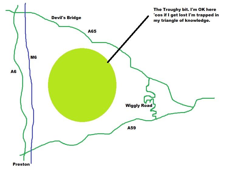
Sharon doesn't understand how this works. I don't need to know exactly where I am as long as I know I'm surrounded by roads I know on all sides. I know if I ride for long enough it's inevitable that I'll have to reach a road I do know. The Trough Of Bowland is a classic example. To the east is the M6 and A6, north east there's the A65 and to the south lies the A59. These roads form a triangle. I only have a vague notion of where things are in that triangle so I often get lost there still I don't fear being lost as sooner or later I must find one of the main roads.
 The quality of my mental map is outstanding I'm sure you will all agree.
We're in the grey area now somewhere near Llay apparently. Coedpoeth? I wonder how that's actually pronounced? Minera, never heard of it. New Brighton? I thought that was on The Wirral?
Navigation by then sun is not going well. Someone keeps on making these roads very very twisty and each time the sun is on my left it immediately veers awkwardly to the right, behind then in front. We are among narrow single track lanes passing through villages and hamlets filled with character and delight that I did not expect to find so close to the city of Wrexham and so close to the English border. This feels rural, remote and truly Welsh in style and this demands we slow down and take in our eye catching surroundings.
Down another single track I start to worry that my mental map may be incorrect then the high hedges and fields fall away and open out to reveal Wales looking as good as I've seen it in a long while. Wow. We're looking along a broad verdant valley lazing in bright sunshine to our left, to our right are steep hillsides with rocky outcrops and swathes of scree below. These are not the angular grand mountains to be found further west, this is a little gentler.
 Wales looks phenomenal as seen from "Panorama Walk"
The narrow strip of tarmac saunters along the hillside, up and down, in and out, over and through. I work out the town below is probably Llangollen so we must surely be on the right track to find The Horseshoe pass and therefore The Pondy. Buoyed by my certainty I follow the road still further. We do pass by some turnings with signposts to places that have no reference in my mental sat-nav but I expect there will soon come a sign to "Horseshoe Pass" or "The Ponderosa". After all that's the only reason people would come to this area, surely?
As we climb another steep brow and navigate a sharp bend I spot a "Ford" sign. Long term readers will know I once had an obsession with fords and to this day they still hold a sweet spot in my psyche. I'm concerned as this has some concrete under the very light and genteel flow of what is essentially a small stream running across the road. The wise 2-wheeled fordist knows this is a recipe for algae and slime which can be very slippery. I inspect the crossing to find it "manageable" which concerns Sharon greatly.
I can see she wants to turn around. I can see she's scared. I assure her I'll walk beside her and assist if any slippage occurs. She enters the water gently as I stand close, preparing to catch her bike(not her, she's more concerned about the bike). Then BRAAAAP!! She nails the throttle and splashes through to the other side. What?! Jeremy Clarkson has nothing on Sharon Parker's approach to any scary situation - "If in doubt MORE POWER!!!" Bemused I walk back to my bike, slipping on the slime as I go. I gingerly cross with a little shimmy and slither, I wonder if Sharon had the right idea and it's my approach that is wrong.
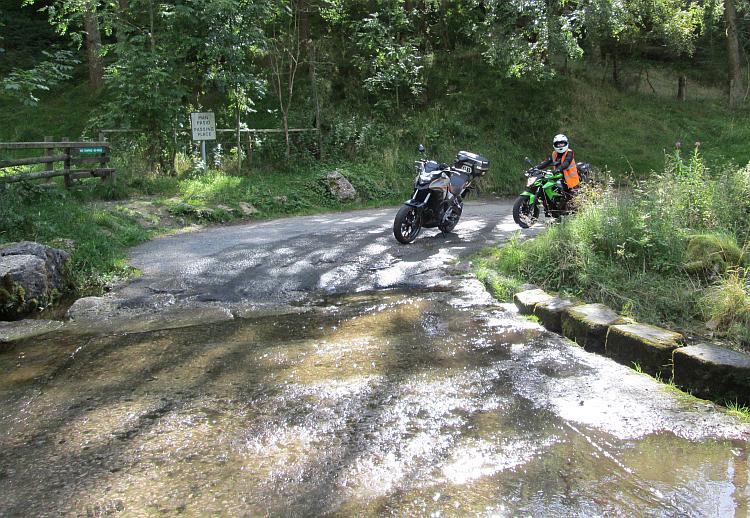 "Oh I'm so scared..." BRAAAAAAP!!!! Scared - my arse
For a handful more miles we ride beside hardy sharp grasses on the moorland then alongside another impressive set of cliff edges until we arrive at a junction that looks rather too familiar. Drat. I'm leading us in circles. Not to worry, it was an amazing circle! Eventually I find the dual carriageway again and lead us another merry dance home in Chester town centre followed by a pleasant soft drink at The White Lion in Alvanley, not too far from Frodsham. We never did get to The Ponderosa.
Of course I realise my mental sat-nav map was wrong. Topologically it was correct but in reality it left quite a lot to be desired. If you wish to compare reality to my mental map the link below will show the area and the beautiful part of the route using Google Maps. Please don't laugh too much, I have a very delicate ego doncha know.
Area and the pretty route - Google Maps.
Days like this make me rethink the whole sat-nav thing I've been hankering after. I would never have accidentally found this enticing little lane if I had not been bewilderingly befuddled. Sat-nav takes you there and that's it job done. Thinking I'm clever then failing spectacularly can be frustrating and it can also be exciting. Some of the best places I've been to have been when I'm lost. That said some of the worst and most scary experiences have been when I've been lost too. If you want the good you have to accept the bad.
I can hear a chorus of "get a sat-nav but only use it when absolutely necessary". Yeah, yes I can see that. Get lost then when the getting lost gets tiresome switch on the sat-nav and get unlost quickly. I, oh I dunno, yes and yet no. You see it's too easy if you have it with you. It's too easy to just get a little bit lost then just sat-nav you're way out. My best analogy is coming home from a long day's work. You know you ought to make a healthy lean chicken stew with all the vegetables but it's just so much easier to get a kebab. You have lettuce on your kebab, that'll make it healthy.
Reader's Comments
Stuart said :-
Hi again. Thanks for the recent articles. I am old school and doing all I can to avoid getting a sat nav. Unless I need to be at a certain place at a certain time I just set out with a rough idea of where I want to go.
One concession I have made though is as a group of us walk long distance footpaths on our days off I bought a Sat Map which is a hand held device that picks up some satellite signals and plots where you are on a OS map.
It fits in the pocket of my riding jacket and when I need to find out where I am I have a quick look at that and set off again in the general direction that I want.
I did agonise about buying it however as I don't like spending money and it wasn't cheap.
Stuart
13/09/2016 22:33:28 UTC
Ren - The Ed said :-
Cheers Stuart. I remember the "good old days" when if you wanted to phone someone you had to remember their number. With the advent of the mobile where all the numbers are stored I for one can barely remember my own phone number let alone those of my family and friends. I've lost a skill.
Sat-Nav would cause me to lose my map reading and navigation skills. With the arrival of new technologies I no longer need to know how to do things because the tech does it for me. For example - writing! I can still write with a pen but I'm a far better typist now that's for sure.
I'm not a stick in the mud. Once upon a time we had Fletchers to make arrows, the gun put an end to that skill. We had poor people peeing into pots and the urine was used in the hide tanning process. Modern chemistry has put an end to that! The point is things move on and skills come and go.
I however LIKE map reading and navigating though so I choose to try and keep these skills, because it pleases me not because I'm a Luddite. What I'm trying to weigh up is whether or not sat-nav would be a useful tool for exploring or perhaps it would spoil the enjoyment I gain from trying to navigate and the random places I find when I am lost.
14/09/2016 10:47:52 UTC
Stuart said :-
I guess that so long as you map read from time to time you won't lose the skill. We met the navigator of an oil tanker when we were on holiday once and he pointed out all of the stars in the sky. Although all of the ship's use computers to navigate they were made to use a sextant from time to time just in case the ship's computers went down.
15/09/2016 10:11:08 UTC
Ren - The Ed said :-
Cheers Stuart. I'm glad important skills like using a sextant are consciously kept alive for the exact reason you state - computers are not infallible.
I think rather than reading a map from time to time I would use a map most of the time and keep sat-nav for those times when I really can't be bothered or I'm in a pickle. Having said all this I rarely use a paper map any more because I'll use the map app on my phone!
It's a balance thing - just like computerised navigation on ships and sextant-clock-compass. Ideally you want both to back each other up.
15/09/2016 11:13:02 UTC
Ian Soady said :-
For the bike I use a paper map in a tank bag or simple tank-top map holder. I've never so far felt the need for satnav although as discussed earlier I have CoPilot on my android phone (and am currently using it in France with the car / caravan and find it very useful).
But these days my use of the car & bike are different. I rarely use the bike for "must do" journeys so am perfectly happy to follow the front wheel and see where it takes me. But I can see the advantage in being able to wander at will then when I want to head for home just firing up the app and letting it take me the shortest / quickest way.
I like your descriptions of mental maps - also the bit about fords, one of which brought me too grief only a couple of years ago. Ironic as there's one only 100 yards from my house but as that is in suburban Brum doesn't suffer from the dreaded algae.
Oh well, back to enjoying myself. A drive over the Col du Tourmalet beckons.......
16/09/2016 10:28:40 UTC
Ren - The Ed said :-
It sounds like a really tough trip this one Ian. Press on through the difficulties I'm sure you'll make it.
17/09/2016 08:29:24 UTC
Name
Comment
Add a RELEVANT link (not required)
Upload an image (not required) -
Uploading...
Home
Ren's Biking Blog